A Tale of 3 Rivers: Intercontinental River Research Collaboration
Back to updatesThe Ocean Cleanup has partnered with leading universities across three continents to study plastic pollution in three urban rivers over three years in the Dominican Republic, South Africa and Thailand.
The mission of The Ocean Cleanup is to rid the oceans of plastic. To do this in the most efficient and sustainable way, we conduct in-depth research around the world aimed at improving our understanding of plastic pollution: what types of plastic find their way into the river, where precisely the plastic enters the river, how it behaves once afloat, and where in the environment it ultimately ends up.
Ridding the oceans of plastic is an ambitious goal, and – alongside cleanup in the oceans – reducing emissions of plastic waste from rivers is essential. Answering the questions above can have a direct and positive impact on our cleaning efficiency: if our research helps us determine (for example) where best to place an Interceptor along a particular river, we hope this will lead to greater Interceptor efficiency – more plastic removal, less emissions into the ocean.
To understand why this research is so vital, it’s worth recalling the scale of plastic emissions into the oceans directly from rivers:
- Approximately 100,000 ocean-bound rivers worldwide
- Around 1,300,000 m3 of water moves from rivers into oceans (enough to fill 500 Olympic-sized swimming pools) every second…
- …carrying with up to 125 kg of plastic downstream – every second.
In the face of such a daunting challenge, it is essential that we gather as much information as possible from as many environments as we can. Due to the huge variation in riverine environments, solid data acquired through long-term comparative studies are of considerable value not only to The Ocean Cleanup, but to the global scientific community tackling ocean plastic pollution.
THREE RIVERS, THREE CITIES, THREE YEARS.
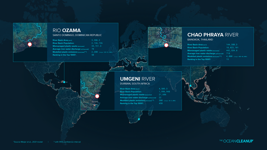
This three-year intercontinental collaboration focuses on the Umgeni river in Durban, South Africa (in partnership with the University of Kwazulu-Natal, or UKZN), the Chao Phraya river in Bangkok, Thailand (with Chulalongkorn University) and the Rio Ozama in Santa Domingo, Dominican Republic (with Instituto Tecnológico de Santo Domingo). These rivers share certain similarities in that they all accommodate highly populated cities, they all lie in the tropics or sub-tropics, they all receive comparable levels of rainfall per year and are susceptible to flooding events, and each features in our list of the modelled Top 1000 most polluting rivers in the world.
Why these three rivers in particular? To study plastic pollution, and ground-truth our monitoring methods, in a variety of environments and contexts. For rivers, one size simply does not fit all. While two rivers may share certain characteristics and may be almost identical in some ways, this does not mean that a single solution will be equally effective in both. Put simply: a solution which may be highly effective at capturing trash in one river may be next to useless in another river, even though the two rivers may share certain characteristics. As we expand our Interceptor portfolio to operate in more and more environments, this data is crucial to guide our scale-up in rivers.
ENTRY POINTS: SATELLITES AND HOTSPOTS
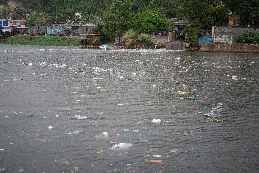
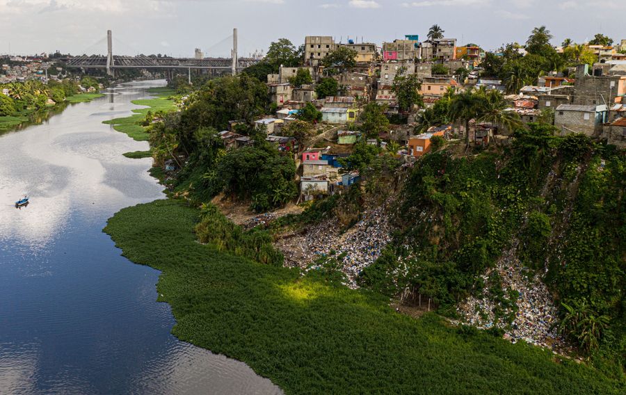
There are multiple ways plastic can enter a river, and identifying entry points can be key in reducing emissions. In South Africa and in the Dominican Republic, our research in collaboration with UKZN and INTEC concerns identifying and monitoring waste entry ‘hotspots’ along the shore, where erosion may result in plastic that was previously on land being washed into a river. Satellite imaging is used to identify hotpots from space, with aerial photography used for corroboration. Once a number of confirmed hotspots are identified (on each the Umgeni and Rio Ozama, more than 10 hotspots are currently monitored), high-resolution drone missions are conducted twice a month to monitor the changes in the natural environment due to weather, and how this variable effects the level and behavior of plastic pollution in the river.
In Thailand and the Dominican Republic, we are examining pollution entry points from tributary canals leading to the main rivers. In Bangkok, Chulalongkorn University is sampling river waste each week to determine how much is contributed by the Lad Luang canal running through the city, alongside a social study of local residents’ behavior and perception of waste management.
Time-lapse cameras are mounted permanently on bridges across all three rivers, including tributaries, to tell us precisely how much debris is moving down the main river and allowing us to extrapolate the potential levels of plastic emissions into the ocean from these rivers and canals, all contributing to our knowledge of the plastic pollution problem.
Combined, this data not only helps us identify the best place to deploy our Interceptors to capture plastic as soon as possible after it enters a river, but will also inform governments to take appropriate measures, as well as increase awareness of long-standing environmental issues impacting riverine communities.
FINDING THE RIGHT PATH
Comparing rivers allows us to expand our dataset and see how specific variables impact our ability to capture plastic. This directly influences our cleaning strategy; the more we learn about where plastic comes from, the better we can optimize our technology and our deployment strategy.
One example concerns the ‘pathways’ that the plastic takes when flowing in a river in a particular location. We would like to answer the question: does the plastic flow right down the center of the river, does it follow the ‘inside track’ like a racecar might, or does it hug the riverbank as it is forced downstream by the current? Answering this question and tracing these plastic pathways allows us to take more targeted and efficient action and maximize the impact of our Interceptors.
Think of it like putting a bucket under a leaking roof; you don’t want to cover the whole floor in order to prevent damage, you simply want to put the bucket in the right place to catch all the water effectively. If you can identify precisely where the leak is, you know exactly where to put your bucket to catch the water immediately, before it can spread all over the floor, causing greater damage and becoming harder to clean. It’s the most effective way to clean up, with the least negative impact.
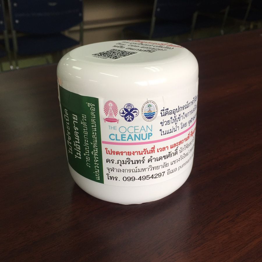
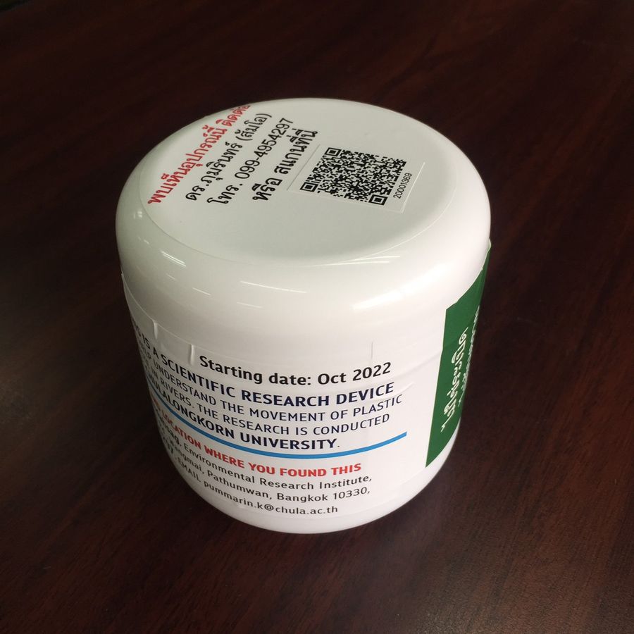
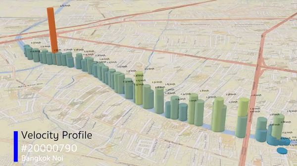
So: does plastic in these rivers flow down the center or does it hug the riverbank? To answer this, we released a series of floating, grapefruit-sized GPS drifters in seasonal batches covering an entire river in a river’s life cycle.
As our research paper shows, the drifters report their position in the river roughly every five minutes to an accuracy of up to 4 meters. This helps us see in real time where plastic is accumulating and measure the impact of specific events such as floods or storms. This information helps us place our Interceptor solutions in the best locations (or configure an existing setup for greater efficiency) for maximum capture: a direct positive gain from the results of our research. In some cases, this may also allow us to limit our coverage of a particular river to less than 100%, leaving space for passing boats and other vessels to pass; this can present challenges to Interceptor deployments as this river traffic is vital in many urban and riverside communities) while maintaining high cleaning efficiency. This moves us closer to a permanent and sustainable solution in that river, and closer to achieving our mission.
Furthermore, this data will help our river modelers better understand how fast and how far river plastic travels – and importantly during which seasons.
MEASURING THE FLOATING RIVER WASTE
The aforementioned bridge-mounted cameras are also used to discover more about the precise nature of the plastic pollution in these rivers. Using AI, the images recorded by the cameras are analyzed to quantify the amount of plastic. This data greatly aids the scientific community to understand better the seasonality of plastic waste being emitted into the oceans from rivers, and share this information in the hope that policymakers upstream can factor this into their mitigation strategies.
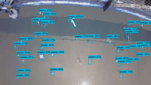
AI analysis of plastic pollution in river
Each set of bridge-mounted cameras – know as the River Monitoring Systems, or RMS – allows us to learn more about the flux of debris in the river, as well as giving us more information about how much waste is organic (i.e water hyacinths) and how much is non-organic (such as plastic, glass and metal). The RMS systems we have deployed in these rivers are large in scale; one of the three deployments on bridges in Thailand features 13 cameras (out of a total of 23 cameras deployed in Thailand) which together can ‘see’ 50% of the cross-section of the river – which is over 260m wide. These cameras take pictures every 15 minutes with each picture 0.25 seconds apart to allow us to measure the speed of the moving debris. AI modeling is then used to identify the debris, give a measurement of the size of individual pieces, and differentiate the various types of waste (i.e. organic and non-organic).
These large operations covering multiple bridges in a single city give us a much more complete picture of where plastic is entering these rivers and how it can be tackled with most impact. More data means our result and findings become increasingly accurate and reliable. Additionally, comparing levels of waste in tributaries with levels found in main rivers, and comparing the levels upstream and downstream within the main river itself, can tell us exactly where plastic is entering the river (i.e. if we see a big increase in plastic between two measuring locations, this likely tells us there is an entry point between the two measuring points). All this data is combined and used to help us formulate the most effective strategy to intercept plastic before it can reach the main river.
NEXT STEPS
This program is in the first year of a three-year data collection plan. We are also intending to explore new options for addressing plastic pollution in these rivers alongside our research – such as Interceptor 004, The Ocean Cleanup’s first river deployment in the Caribbean which has been removing plastic and gathering data in the Rio Ozama in Santo Domingo since 2021. In Durban, the local Litterbooms project can serve the same function. Meanwhile, additional in-situ sampling using nets and dredging will help us understand the role of surface, water column and riverbed sediments as bearers of plastic waste. We’ll also be surveying waste that washes onto beaches close to the mouths of these rivers to learn more about the impact on the local coastal environment.
Plastic pollution is a human-made problem, and cleanup is only one part of the solution. Better understanding the socio-economic factors which lead to plastic pollution is key to stopping plastic pollution upstream, ideally before cleanup becomes necessary. Therefore, our research extends beyond the environmental scientific realm and into the social scientific domain. In Bangkok for example, described above, our expert colleagues from the Social Research Institute at Chulalongkorn University have already begun. We aim to deepen our fundamental understanding of river plastic pollution processes, and identify relevant socio-economic factors to refine our local and global models and improve the impact of our plastic interception program worldwide. The data generated from our observational network can support the development and implementation of national and international schemes and policies to tackle plastic pollution at source, with the hope that one day soon these rivers will be free of plastic, and our Interceptors will no longer be required.
This research project is supported by our partner Tito’s Handmade Vodka
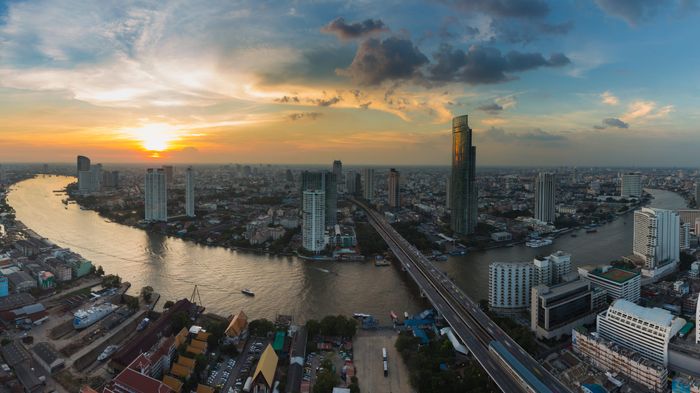
Header image: Focus for research and cleanup: the busy waterways of the Chao Phraya River meandering through the metropolis of Bangkok before at sunset (iStock / Getty)